|
|
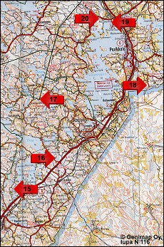
Site Map: Sites 15-20
|
16-17. Haukkavuori Hill and the Torsansalo border stone in Rautjärvi
The border between the Swedish and Russian empires ran through Rautjärvi for hundreds of years. Today historical border markers tell of where the border ran. A border marker for the Uusikaupunki Peace Treaty (1721) is carved into a stone beside Rautjärvi's Torsansalo road. The border ran across Haukkavuori Hill at three different times: the Pähkinäsaari Peace Treaty of 1323, the Täyssinä Peace of 1595, and the Uusikaupunki Peace of 1721. A border marker for the Uusikaupunki Peace Treaty has been carved into the rock at the site. Haukkavuori Hill is the highest point in South Karelia.
After the battles for possession of Karelia, the prehistoric period ended with the Pähkinäsaari Peace Treaty of 1323. The treaty divided Karelia and part of Finland between the empires of Sweden and Novgorod. For hundreds of years the Pähkinäsaari border line marked Finland's eastern border.
Borders were usually indicated by carving border markers into stones or rocks, but piles of stones and even large trees were also used as markers.
Driving directions:
Torsansalo border stone
Turn off Highway 6 towards Torsansalo. Continue for 1.1 km. The site is immediately on the right side of the road. Cars or a bus can park along the road.
Haukkavuori Hill
Turn off Highway 6 towards Torsansalo. Drive 20 km and turn right towards Haukkavuori. There is a parking area from which you walk about 700 metres to the top of Haukkavuori Hill.