SisältöYhteystiedot
#
1. Sailing barriers in the Rannuusinsalmi Strait in Suomenniemi
2. Hill fort in Kuivaketvele, Taipalsaari
3. Voisalmi machine gun and accommodation bunker in Lappeenranta
4. Kauskila cemetery in Lappeenranta, from the time of the Crusades and the Early Middle Ages
5. Stone-Age dwelling site at Murheistenranta in Lappeenranta
6. Saarenoja Stone-Age dwelling site in Joutseno
7-8. Stone-Age dwelling sites on Lammassaari Island in Imatra
9. Stone-Age dwelling site in Ukonniemi in Imatra
10. Rock painting at Kolmiköytisienvuori in Ruokolahti
11. Huusniemi Stone-Age dwelling site in Joutseno
12. Stone-Age settlement dwelling site on Mietinsaari Island in Joutseno
13. Korosniemi prehistoric settlement in Ruokolahti
14. Lapp cairn at Salminiemi in Ruokolahti
15. The Viking Age cemetery at Hirnilä in Rautjärvi.
16-17. Haukkavuori Hill and the Torsansalo border stone in Rautjärvi
18. Cup stone from Silvu in Parikkala
19. Stone-Age habitation of Parikkala / Stone-Age dwelling site at Haljakka
20. Pitfalls on the Romanonkangas Heath at Parikkala
21. Cultural landscape at Tarnala in Saari
22. Orthodox village of Papinniemi in Uukuniemi
23. Stone-Age burial ground and dwelling site at Vaateranta in Taipalsaari
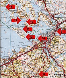
Site Map: Sites 6-14
7-8. Stone-Age dwelling sites on Lammassaari Island in Imatra
Dwelling site no. 1 on Lammassaari Island was probably inhabited during the Typical Combed Ware period some 5900 - 5400 years ago (3900 - 3400 B.C.). Pieces of pottery have been found at the site. Sharp stone chips, created when stone objects are being made, have been found at dwelling site no. 2 on Lammassaari Island.

The Lammassaari dwelling sites are located at the mouth of the Vuoksi Channel. The massive Saimaa waters broke open a new outlet channel, the Vuoksi of Imatra, about 6000 years ago. Lammassaari dwelling site no. 2 was probably in use when the Vuoksi Channel burst open, and dwelling site no. 1 probably after the Imatra Vuoksi outlet channel had opened, because it is located slightly below the Saimaa's highest flood crest.

Driving directions: Take Lammassaarentie road towards the Imatra Spa but drive past the spa toward Lammassaari. Site 7 and a sign appear on the left after the dike path as you approach the island. From there it is about 600 metres by foot to site 8. Cars or a bus can park along the road.