SisältöYhteystiedot
#
1. Sailing barriers in the Rannuusinsalmi Strait in Suomenniemi
2. Hill fort in Kuivaketvele, Taipalsaari
3. Voisalmi machine gun and accommodation bunker in Lappeenranta
4. Kauskila cemetery in Lappeenranta, from the time of the Crusades and the Early Middle Ages
5. Stone-Age dwelling site at Murheistenranta in Lappeenranta
6. Saarenoja Stone-Age dwelling site in Joutseno
7-8. Stone-Age dwelling sites on Lammassaari Island in Imatra
9. Stone-Age dwelling site in Ukonniemi in Imatra
10. Rock painting at Kolmiköytisienvuori in Ruokolahti
11. Huusniemi Stone-Age dwelling site in Joutseno
12. Stone-Age settlement dwelling site on Mietinsaari Island in Joutseno
13. Korosniemi prehistoric settlement in Ruokolahti
14. Lapp cairn at Salminiemi in Ruokolahti
15. The Viking Age cemetery at Hirnilä in Rautjärvi.
16-17. Haukkavuori Hill and the Torsansalo border stone in Rautjärvi
18. Cup stone from Silvu in Parikkala
19. Stone-Age habitation of Parikkala / Stone-Age dwelling site at Haljakka
20. Pitfalls on the Romanonkangas Heath at Parikkala
21. Cultural landscape at Tarnala in Saari
22. Orthodox village of Papinniemi in Uukuniemi
23. Stone-Age burial ground and dwelling site at Vaateranta in Taipalsaari
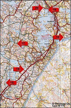
Site Map: Sites 15-20
20. Pitfalls on the Romanonkangas Heath at Parikkala
A pitfall is a pit dug into the earth, usually into sand, to trap elk or wild reindeer. At good places there may be from one to several hundred pits, and they may be laid out in lines. Dating shows that pitfalls were made from the Stone Age to the time of recorded history.

The Romanonkangas Heath has two lines of pitfalls, with a total of more than 30 pits. The pitfalls were discovered in 1995. They are on a sandy heath which was once bordered by a swampy hollow on one side and the Romanonjoki River on the other. Two rows of pitfalls cross the heath with a distance of about 150 metres between them. The diameter of the pits averaged 2-4 metres and they were usually about two metres deep. Today the pits appear as gentle depressions ranging in depth from twenty-some centimetres to about a metre. The Romanonkangas pitfalls have neither been studied nor dated.

Driving directions: At Särkisalmi, turn from Highway 6 onto the road to Melkonniemi (no. 4052). Continue about 3.6 km. On the left there is a sign to "pitfalls" and a lay-by with parking. From there it is about 300 metres by foot to the site.